We remain fully operational. Our teams are working around the clock to ensure your deliveries continue safely.

下载应用程序


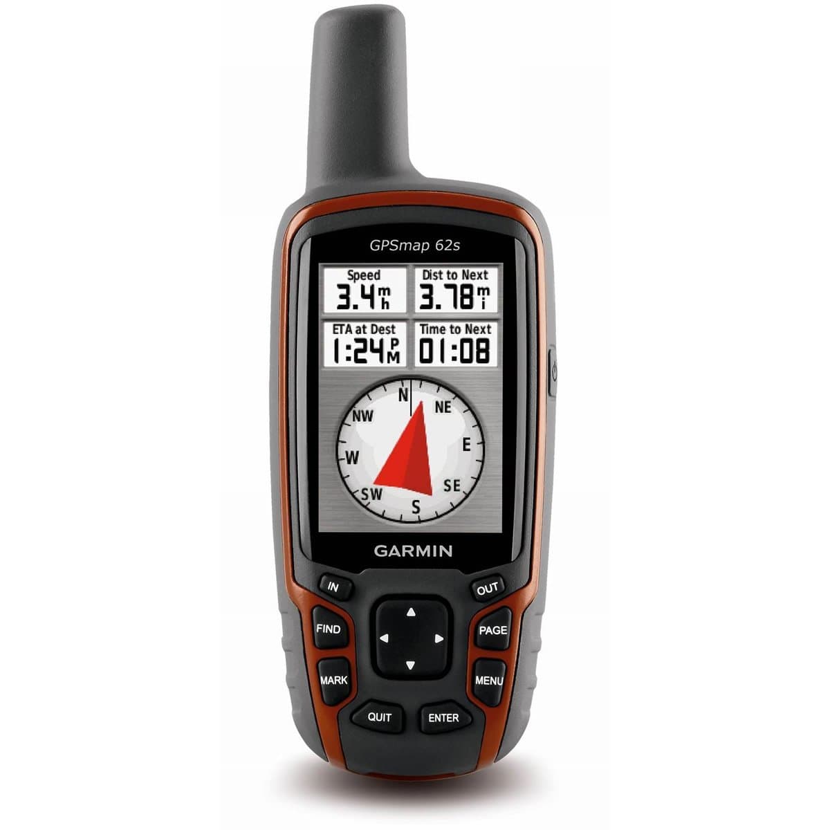
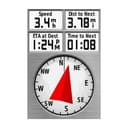

🧭 Unlock your path with Garmin GPSMAP 62S — where precision meets adventure
The Garmin GPSMAP 62S is a rugged, waterproof handheld GPS navigator featuring a bright 2.6-inch sunlight-readable display, a 3-axis tilt-compensated compass, barometric altimeter, and a quad helix antenna for fast, accurate satellite reception. With 1.7GB onboard memory plus a microSD slot, it supports extensive topographic, marine, and road maps, along with wireless sharing of waypoints and geocaches. Designed for serious outdoor professionals and enthusiasts, it offers up to 20 hours of battery life and customizable navigation options, making it the ultimate tool for geocaching, hiking, and outdoor photography.
| ASIN | B003IHV6YG |
| Additional Features | Barometric Altimeter, Custom Pois, Garmin Connect Compatible, Geocaching, Hunt-Fish Calendar, Photo Navigation |
| Are Batteries Included | No |
| Battery Average Life | 20 Hours |
| Best Sellers Rank | #308,769 in Electronics ( See Top 100 in Electronics ) #330 in Handheld GPS Units |
| Brand | Garmin |
| Compatible with Vehicle Type | Car, Truck |
| Connectivity Technology | USB |
| Control Method | Push Button |
| Customer Reviews | 4.2 4.2 out of 5 stars (420) |
| Display Type | TFT |
| Global Trade Identification Number | 00075375910087, 00753759100872 |
| Human-Interface Input | Buttons |
| Item Weight | 0.21 Kilograms |
| Manufacturer | Garmin |
| Map Types | Street;Topographical |
| Memory Storage Capacity | 1724 MB |
| Model Year | 2010 |
| Mounting Type | Dashboard Mount, found in image |
| Operating System | Windows |
| Resolution | 160 x 240 |
| Screen Size | 2.6 Inches |
| Supported Satellite Navigation System | GPS |
| Touch Screen Type | Resistive |
| UPC | 168141454974 075375910087 803982785916 763615874441 617407543117 753759100872 |
| Warranty Description | 1 year limited |
W**E
Better Than Expected
After reading many of the reviews here, I was expecting to have some issues with the 62s, but I went ahead and bought it because a friend had one and it passed his high standards. So far, I've only had one small problem with it. I got the 62s to replace my 60csx because I wanted a better device for geocaching. In that regard, it is a vast improvement over the 60csx. I used to have to take my smart phone with me and use both devices to find a cache. Now, the 62s has all the information I need. When I got the device, I plugged into my OS X computer and brought up Base Camp. It immediately told me there was a software update. I had to download an app from Garmin to do the update. After doing so, the upgrade was a breeze. I also uploaded a non-garmin map to it using Garmin Map Install without any issues. Some reviews complained of a difficult interface. After the 60csx, I found it easy to use. It only took me a few minutes to get comfortable with it. Full disclosure: I have 40+ years programming experience and was the go to guy to assemble toys at Christmas. The interface is more complex as there are more options. For regular use, you generally don't have to access them. A nice improvement is the ability to customize the interface. I dropped several screens from the standard rotation making it easier to get to the ones I want. The only problem I have with the interface appears to be a bug in paging. At the completion of a search for a geocache that I decide to cancel by selecting Stop, I can't navigate to another page. When I press Page, I see all the other pages and can select one. When I do, it just returns to the compass page. The way around the problem is to select the compass page first. After that, it works fine. My friends 62s doesn't do this. I also read about complaints about the case creaking. I don't have this problem with mine. This may have been something they fixed in production since the product came out. I also read complaints about the battery level indicator going from full charge to no charge quickly. I've only discharged it once. The device was at full charge when I started out on my last outing. I wasn't checking the charge as I went along until I got a message that the batteries were low and that the back light would be turned off. At that point, the charge was down to two bars. I continued to use it for about an hour until it got down to one bar. At that point, I put in new batteries. I'm guessing I could have used it for a while longer before they went completely dead. Overall, I didn't find the performance any better or worse than my 60csx. I use alkaline batteries and my usual practice is to always carry an extra set with me when I'm out with the device. There appears to be one drawback in comparison to the 60csx when using the device to feed coordinates to a camera. They still supply a cable to do that, but it plugs into the USB port. From the look of the cable, it would stick straight out of the device like any other USB cable so you have to leave the flap open. My concern is that it would get in the way and be subject to getting bent. The cable for the 60csx plugged into another socket and came out at a right angle to the device. Another disadvantage of the new cable is that the other end is just bare wires. You would have to solder on a connector of your choice. My solution was to buy another GPS that mounted on my camera hot shoe. Even with the 60csx, the cable between the Garmin and the camera was a pain. In use, the 62s seems to lock onto to satellites faster than the 60csx and is slightly more accurate in zeroing in on a cache. These are just my opinions; I haven't done any formal testing. With both devices, I had problems in heavy tree cover. Overall this device is a vast improvement over the 60csx for the purpose of geocaching. My only complaint is the problem with the page switching,which hopefully can be fixed.
C**E
Garmin® GPSMAP 62S Handheld GPS Navigator
I purchased the Garmin® handheld GPSMAP 62s navigator after weeks of research. First, let me state that I already own a 265wt GPS and enjoy it very much. I purchased the 62s unit because, being a nature and outdoor photographer, I wanted a handheld GPS unit that I could plan my shoot and/or mark my path and follow it back to my starting point. After losing my way a couple of time on deep forest photo shoots, I felt it was worth the investment. I agree with all the other reviewers how great this unit is. So, I won't repeat them. In my opinion, it is the standard, there is no better and Garmin® support is excellent. I have called them on at least three occasions. They are always friendly and helpful--what you'd expect from number one! That being said there are issues that one should be aware of. While you have great hardware and support, the learning curve is long. Out of the box you receive nothing but the 62s GPS, a USB cable that is too short [19" to be exact] and a "quick start manual." You're totally on your own for everything [Basecamp©, mapsource© and their use]. You must acquire and figure out how to use the new 62 series GPS yourself. The downloaded "Owner's manual" is almost useless. It's like a manual for your car! It tells you how to open the door, roll down the window, where the headlights are, etc. You look at it once, put it in the glove compartment and that's it. There are improvements in firmware from the 60 to the 62 series. I do like the 62s's menu structure. You can expand it or contract it, change the order as desired. It floats, in that when you press page or quit, the menu applets show up on the screen and move forward or reverse direction. The file structure is totally illogical. Many functions are NOT where you would think they are and you struggle again and again. For example, I use the tide chart along with sun rise/set data to plan shoots. First, tide data is not mentioned at all in the manual. I had to call support. It's under "find." And there is NO explanation of the file system explaining how/where to store files/maps, internal memory or external [SD] memory or how to upload or download a route or waypoints. The best source I have found is GPSFILEDEPOT at [...]. I added a 16gb microSD card and installed NA City Navigator maps and SE Topo maps. I also purchased the BirdEye® maps but think they are useless. For a given area, they require too much space. There is a limit of ~500mb that you can download from the server at one time. In summary, this is a great unit in spite of afore mention issues. You will either spend many hours searching the web for solutions or have a mentor that can assist in learning.
E**G
Beautiful piece of equipment, but complicated to use
Previously I was using a Garmin 100. I was looking for a GPS which was more sensitive to receiving the satellite signals, but I was happy with readily accessible inform provided by my 100 which was simple to operate. The 62s has a maze of options, much more than I need. It was easy enough to create and save a track. In too many cases I've found the instruction manual to be poorly written (in at least one case, the instructions may be wrong for the 62s). Simple things such as battery level and distance travel for the current track require multiple steps. I still haven't figured out how to get basic data about a saved or archived track (for example, distance traveled). There is a basic map that comes with the 62 which is satisfactory for me, except that it is about half-mile off. Yesterday when I was kayaking on a river, the map showed me at least half-a-mile away sometimes on a highway. I'll keep working with the unit--surely with more experience I will be able to enjoy it. My 62 definitely receives the satellite signals well even inside my house. Yes, I regret buying the 62s.
F**S
ottimo prodotto in una categoria in continua evoluzione, attenzione questo è il modello di punta senza cartografia precaricata (con un minimo di dimestichezza si trova facilmente online da scaricare anche la versione open source) e senza la fotocamera integrata. Secondo me è il miglior modello per chi non ama il touch screen (montana) e non vuole spendere centinaia di euro in piu per fotocamera e mappe precaricate. E' estremamente pratico e sembra robusto, ottimi i tasti grossi utilizzabili anche coi guanti, la durata delle batterie (comuni stilo) a me dura piu di tre giorni. A dire il vero utilizzandolo solo quando 'serve' potrebbero durare molto di piu. Prende egregiamente il segnale e in modo rapido. Non lo ho usato in auto come navigatore (credo che non sarebbe il massimo soprattutto con la cartografia open source) ma solo in trekking. Uniche pecche: -schermo che mi si è già un po rigato (immaginarsi il modello touch screen...) -funzioni 'avanzate' richiedono secondo me un po di studio sul manuale online, intuitive invece le funzioni base. Consigliato
あ**ま
単独登山をする方は、必携だと思います。 カシミール3Dとの相性が、非常に良いです。 【良い点】 ・単三乾電池2本で動作します。 コンビニさえあれば、いつでも補充できますね。 ・最高使用時間24hというのも、安心。 ・旧GPSですと、水平に持ち運んでログを集積しないと精度が 上がりませんでしたが、GPSmap62sは、斜めに持ち歩いても大丈夫だそうです。 ・登山中は、手が汚いです。でも、GPSmap62sにスリップケース装着すれば、 本体は全く汚れません。 ・遭難や迷子の確率が、確実に下がります。 【注意すべき点】 ・ショップによって、ショップオリジナルの日本語マニュアルを、 付けてくれたり付けてくれなかったりします。 ・地図は、付いていません。 マイクロSDに地図を落として、装着します。 噂では、日本語地図は、日本語GARMINでしか活用できないそうです。 ・マイクロSDの地図は、別のモールで買いました。。。 【私の使い方】 PC用に、「改訂新版 カシミール3D入門編」と「改訂新版 カシミール3D GPS応用編」を購入し、 地図を結合する事を、強くおすすめします。 地図の結合の方法は、下記です。 1.「改訂新版 カシミール3D GPS応用編」をインストール 2.「改訂新版 カシミール3D入門編」の地図フォルダを、1.で生成された同じフォルダに上書き。 3.その後、「改訂新版 カシミール3D GPS応用編」にある2.で上書いたフォルダに、 もう一度、対象のフォルダだけ上書き。 こうすると、関東甲信越〜沖縄までの、1/25,000 がPC上に網羅されます。 登山に1/25,000 が必要なのは、周知の事実。 国土地理院では、GPS連携しないし、、、 やはり、カシミールはすばらしいです。 以下、私の愛用カシミール&GPSmap62sフロー。 ・カシミールでWay_Pointを、とにかくたくさん作る。 ・Way_Pointを連続クリックしてカシミールの断面図を作り、ペース配分を検討する。 ・PC→GPS へ、Way_Pointをインターフェイス。 ・登山する。 ・GPSログのカレントデータを、PCへ。 ・一眼のフォトも、カシミールに足してみる。 ・なぜに登山にこんなに時間がかかったのか、反省する。 ・ヤマレコにあげる。 …、単独登山は反省の嵐です。 でも、このフローを踏まないと、遭難して、もっと反省する事になると思います。 楽しい空の旅を。 ジェットエンジンではなく自分の足で。 改訂新版 カシミール3D入門編 改訂新版 カシミール3D GPS応用編
K**O
i bought this for walking , cycling , and to use on motorbike (so needed to be waterproof and in car) , an all round gps ... i love it ... its not just where am i , which way do i need to go , it's a trip computer , altimeter , if you buy the heart rate monitor and cadence sensor , it's a training aid . you will need to buy a micro sd map card to get the most out of it , i bought garmin gb discoverer north england and midlands from go outdoors at sheffield , cos they had it on offer ... i wasted £20 quid buying a tiny square of birdseye select 1;25k scale map , dint really need it , cos 1;50k is pretty good too ... it has different modes , automotive , recreational , geocaching etc , all customisable , is nice to use , but not something you can just pick up and already now how everything on it works , but having said that , you don't really need instructions either... like a mobile phone , first day or so , you set it up and mess with it until you got it how you want it. the gps system on the road in automotive mode , will work like a normal car sat nav , but with beeps instead of voices (with map sd card) ... off road , it doesn't calculate your route , how could it really , footpaths , tracks in woods , all the right of way stuff they'd have to keep checking to not get sued... it guides you by an arrow ,your at point "a" and it'll pointin a straight line to point "b" and you use the maps on the screen to make your own route to your destination,just follow to paths that go in a similar or same direction as the arrow , all you need... the best thing for me about the gps map 62s , is the geocaching feature , i didn't even know what it was until i bought this , now i'm hooked ... also shows how accurate the gps map 62s is , even in heavy woods with thick snow clouds above , love it.
O**R
On me l'a volé, j'ai racheté le même sans aucune hésitation : ça veut tout dire ! Il est excellent. Captation rapide des satellites même en sous-bois et par ciel couvert (utilisé en toute fiabilité en forêt amazonienne), très bonne ergonomie des menus, touches agréables, écran clair... Outre ses caractéristiques techniques, j'apprécie particulièrement le mousqueton (livré avec) qui permet de le garder à la ceinture ou attaché à la bretelle du sac à dos, sans aucun risque de le perdre ce qui était ma hantise avec mon premier GPS. Au fait : possédant également un modèle d'une grande marque concurrente (je ne la cite pas mais on l'aura reconnue !), je recommande ce Garmin fortement !
I**O
Bueno, resistente, y fácil de usar. Se enciende rápidamente y la resolución de las imágenes satélites esta muy bien. Y junto con el software es muy útil para planificar sus rutas.
TrustPilot
1 个月前
5天前