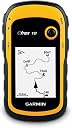
GARMIN(ガーミン) ハンディ GPS eTrex 10 【並行輸入品】
Product ID: 736971694
Details
- オーディオ出力モードDigital
- ブランドガーミン(GARMIN)
- マップタイプサテライト ワールドワイド
- モデル名eTrex 10
- 付属コンポーネントeTrex 10 USB
- 接続技術USB
💧IPX7 waterproof rating
📍1000 waypoints storage
🔋25h battery life
Desertcart purchases this item on your behalf and handles shipping, customs, and support to Taiwan.
📡 Stay on track, rain or shine — the ultimate GPS sidekick for your next adventure!
The GARMIN eTrex 10 is a durable, waterproof handheld GPS device featuring high-sensitivity GPS tracking, storage for 1000 waypoints and 50 routes, and a 25-hour battery life. Its USB mass storage interface eliminates driver installation, while the compact 2.2-inch monochrome display ensures clear visibility outdoors. Designed for rugged use, it supports over 100 geodetic datums and offers essential trip computer functions, making it a reliable companion for hiking and outdoor navigation.
| ASIN | B00542NV32 |
| Amazon 売れ筋ランキング | スポーツ&アウトドア - 181,440位 ( スポーツ&アウトドアの売れ筋ランキングを見る ) トレッキング用GPS・アクセサリ - 136位 |
| GTIN (Global Trade Identification Number) | 00753759975845 |
| OS1 | Android |
| UPC | 753759975845 |
| おすすめ度 | 5つ星のうち4.3 6,314 レビュー |
| オーディオアウトプットモード | Digital |
| タッチスクリーン、声認識、他の有無 | ボタン |
| タッチ画面タイプ | 静電容量方式 |
| ディスプレイの種類 | 液晶 |
| バッテリー付属の有無 | いいえ |
| バッテリ平均持続時間 | 25 Hours |
| ブランド | ガーミン(GARMIN) |
| ブランド名 | ガーミン(GARMIN) |
| メーカー名 | Garmin |
| メーカー型番 | 0100097000 etrex 10 |
| モデル名 | eTrex 10 |
| ユニット数 | 1.00 個 |
| レンズマウントの種類 | ハンドヘルド、ハンドルバーマウント、ダッシュボードマウント |
| 同梱商品 | eTrex 10, Lanyard, USB cable, Manual |
| 品目寸法(L x W x H) | 10.3長さ x 5.4幅 x 10.3高さ cm |
| 商品の追加説明1 | 防水 |
| 商品の重量 | 141.7 グラム |
| 地図タイプ1 | サテライト, ワールドワイド |
| 型番 | 010-00970-00 |
| 対応する衛星測位システム | GPS |
| 接続技術 | USB |
| 最大メモリ容量(GB) | 6 MB |
| 特徴 | 防水 |
| 画面サイズ | 2.2 インチ |
| 画面サイズの単位 | 2.2 インチ |
| 発売年・モデルイヤー | 2011 |
| 管理方法 | タッチ |
| 車両の種類と互換性がある | トラック |
| 通信・接続インターフェース | USB |
| 適合車両のタイプ | トラック |
A**R
Very good item.
Thank you!
T**M
ロガー限定として使えば
ロガーとして使えば満足です。 入っている地図は使い物にはなりません。(大阪、名古屋、東京、などの都市と日本の輪郭が入っている程度) 別途地図を入れる方法もありますが、なにぶんメモリが少ないので実用性は低いと思います。 私の場合は単なるGPSロガーとして使用し、結果をPCに取り込んで処理しています。 単なるGPSロガーとしてなら申し分有りません。 固定に関しては、携帯電話についているような、細いヒモを通す穴が開いています。 他に固定する手段が無いのでオプションのパーツの購入をお勧めします。私は純正のカラビナがつくタイプのものを使っています。
F**T
緯度経度の表示が早いが、メニュ-移動のジョウスティクには慣れがいる。
以前使用していたGEKOに比べて、位置の補足表示が格段に早い。樹林帯でもすぐに緯度経度が出てくる。 地図が入らないので、位置表示に割り切って使ってます。
3**O
必要十分
初代のeTrexを壊してしまったので購入しました。 初代が油断するといつの間にか接触不良で電源が落ちていることが屡々有りましたが、これは電池の持ちも改善して、丸一日 ニッケル水素電池が無くなるまで撮影中の間起動し続けてくれました。 アンテナ感度も上がっていて、初代からの正常進化を感じられて、データーロガー&元の場所に戻るという私の使い方には必要十分で大変満足しています。
ハ**ー
私の場合はキノコ探しに使うのでこれで十分ですね! 英語や機械が苦手な人は日本語表示の正規品がオススメです、カーナビの様に簡単ではありません。
私の場合はキノコ探しに使うのでこれで十分ですね! 英語や機械が苦手な人は日本語表示の正規品がオススメです、カーナビの様に簡単ではありません。
A**ー
最初の言語のセットに留意
電池を入れ最初に触ったボタンでアラビア語。再設定に往生こいた。先ずはゆっくりマニュアルを読んで、ほとんどの日本人は、英語しか選択の余地がないと思うが。でも外歩きで安いのは、紛失したとき(小生3回目)助かります。(高いのは3-4個以上あり)あとは、雨中で検証です。日本の導きは捕捉できないけれどロシアの衛星も捕捉できるよ。
A**ー
よかったです。
英語版のため価格が安くて良かったです。 セーリングクルーザーのデッキ上での使用のため、小型で壊れにくく、たまに海上に落とすこともあり、この価格は助かります。 旧モデルから3台目です。
B**S
マジありえん
・記録したデータがしょっちゅう勝手に消える。マジありえん。 ・データ転送しても勝手に消える。マジありえん。 ・内蔵メモリ8M。マジありえん。昭和か。 ・金返せ。
D**D
Justo lo que necesitaba
No tiene lujos ni aplicaciones extraordinarias, pero es perfecto para hacer rutas senderistas con la seguridad de no perderte. Es ligero , de pequeño tamaño. no pierde la señal del satélite ,. La pantalla se ve perfectamente con sol y sombra y su manejo no es muy complicado. Por ponerle un pero, para mi gusto le falta un bloqueador de pantalla, pero aún así, muy buena adquisición,
F**O
Ottimo gps
che devo dire ottimo gps. Rispetto agli atrli modelli della garmin sicuramente è più semplice, ma per una passeggiata nei boschi è perfetto. Non ha mai perso il segnale, è facile da utilizzare per i soldi che costa è ottimo. Ripeto è la versione base, il display non è a colori, non è cartografico ma mi ha riportato sempre dove avevo lasciato la macchina, e i punti registrati anche se immersi nel bosco, quindi magari con poco segnale sbagliano di un paio di metri, ma stiamo parlando di punti registrati dove i cellulari fanno fatica a prendere il segnale... per il resto molto comodo, non è pesante, ottima la cosa che è alimentato da semplici pile stilo, quindi si cambiano facilmente in caso di necessità. Lo schermo si vede abbastanza bene anche di giorno, l'unico difetto che poi non è un difetto è che tutto il gps è comandato da la levetta in alto, essendo abitutati agli schermi touch ogni tanto io ancora spingo lo schermo...ma è una questione di abitudine. Per il resto autonomia, praticità semplicità è consigliatissimo. Per chi non è interessato ad avere la cartografia, ma un gps che senga punti di interesse, che ti mostra il tracciato che hai fatto, che volendo ti fa ripercorrere tutto il tracciato indietro, che prende benissimo, che consuma poco allora non pensateci due volte a procedere all'acquisto, dato anche il costo...perchè si avere un gps a colori, cartografico ecc può essere anche bello, ma se andate per boschi a funghi e lo perdete oppure vi si rompe....un conto perdere un modello base un conto il top. Consiglio la acquisto a tutti quelli che necessitano un gps non cartografico
J**T
Reviewed by a cyclist for cyclists considering this device for their bicycle riding.
This device (the eTrex 10) is a gem. Thus the five star rating. I've been studying it and using it on bicycle rides for the past two months. I've read several of the Amazon reviews for this product, and few do a good job of informing the consumer. I think this is because the product caters to so many different endusers: boaters, kayakers, walkers, hikers, off-road cyclists, and on-road cyclists. My review is written from the perspective of an on-road cyclist. And I'm not going to write a review as much as merely answer a series of questions. 1. Can you charge this device using a USB cable? >>No. The device uses two AA batteries for power. They can be cheap alkaline, or the more expensive rechargeable NiMH or lithium. Alkaline work ok if the weather is warm or hot. If you go the rechargeable route, don't buy cheap ones that have less than 2000 capacity. I didn't know rechargeables came in different capacities. Duh! The rechargeable batteries you need to recharge in a separate recharging device. 2. What do you use the USB cable for that comes with the device? >>To connect your device to your PC or Mac so you can update software or move GPX files on or off the device. GPX files are what tracks and waypoints are stored in. I use a Web site called RidewithGPS to create my TCX files. Then I use other software to convert them to GPX files. Think GpsVisualizer dotcom. 3. Can you load maps into this device? >>Not really. There is an almost nonexistent base map that comes with the unit. It is supposedly possible to overwrite it with a different map. However, for you to add maps to this device you would need to be able to insert an SD card which is where you would store extra maps. Since you cannot install an SD card into this device, you cannot add maps. 4. Can you use this device on long bike rides so you don't get lost? Is it good for bicycle touring? >>Yes. This is why I purchased this device. 5. Can this device aid one in navigating a city walk? An outdoors hike? An off-road bicycle ride? An on-road bicycle ride? Yes to all four questions. I use the device for GPX files I create using a free online service called RidewithGPS dotcom. The GPX files are the end-product of designing a route. Some of the routes are through city streets. Some are through trails in the various outdoor parks near my home. Some are mountain bike trails. And some are 200k brevet rides on roads. I copy the GPX files into the GPX folder in my device and I'm ready to go. 6. Can an SD card be installed into this device? >>No. Not on THIS device. Pay a little more to get the eTrex 20x or the eTrex 30x and you will be able to install an SD card in those devices. 7. Is it easy to read this device in sunlight? At nighttime? >> Yes. Yes. I have found it easy in both daytime and nighttime. Of course, I have to wear glasses that correct my vision well. The viewing screen is somewhat small. 8. Is this device good for long distance bike rides like brevets? >>Yes. GPS navigational devices designed for cyclists typically have internal rechargeable batteries that will die after 10 to 12 hours of constant use. Since the eTrex 10 uses two AA batteries, when they die they are easily replaced while riding the bike. As long as you have extra AA batteries along during your rides you will never be without a functioning eTrex 10. 9. How long does it take to find satellites before it starts working? >>Depends. It always cranks up quickly (within a minute) for me. However, I have both kinds of satellites enabled in my system setup. Uses more power this way though. 10. Is the user manual instructive? >>It is OK. The problem with the manual is the uses the device can be put to are so broad: boating, walking, hiking, biking off-road, and biking on-road. There really should be a manual for each type of user – and there just isn't. Furthermore, do you want to use the device to mark geocaches? To merely be a navigation tool? Or to record where you have gone so you can retrace your steps? I'm really only interested in using the device as a navigation tool. 11. Does this device track pace and distance traveled? Can it double as a bike speedometer? >>Yes. Yes. You can configure the view screen to tell you how far you have traveled at any point in time. And you can configure it to tell you how fast you are going in mph or kph. 12. How relevant are street signs when using this device? >>Street signs are not really relevant because maps are not really relevant. With this device and your GPX file you will have a track (breadcrumb trail) and waypoints (usually along the trail). I create my GPX file so the names of the waypoints are street names. When the device is functioning a cursor shows up in the view screen indicating where I'm actually planted on the earth. As it moves along the track and I approach a waypoint I know it'll be time to make a turn. I can make the turn without even knowing the name of the street. And when riding in the middle of the night I rarely look for street signs to verify a turn. Of course, it is nice to see a street sign that matches the waypoint title. Waypoint titles show up in my view screen as I ride. 13. Does the view screen easily scratch? >>Yes. This is a problem. Invest in a $10 screen saver. 14. Does this device provide turn-by-turn instruction when being used? >>No. You only get turn-by-turn instructions when a GPS device uses an installed map to "calculate" your route. This device doesn't even have a map. But the eTrex 20x and eTrex 30x models do have maps. However, those units don't use the maps to calculate routes. The maps are just background images to the tracks and waypoints that appear on the respective view screens. All three units allow you to create proximity warnings around your waypoints. And when you get within a certain proximity of a waypoint you can be warned. This function works kind of like turn-by-turn instructions. Unfortunately, I have found them not to be too helpful. They tend to clutter up my view screen. 15. Can you insert a pre-loaded route? >>Yes. See answer to Q12. 16. What kind of battery life can one expect? >>With two rechargeable NiMH AA batteries with capacity of 2600 each you'll probably get more than 20 hours. This has been my experience while having both types of satellites accessed and leaving the backlight on constantly. 17. Does this device have touchscreen features? >>No. If it did you wouldn't get 20 hours of battery life. See answer to Q16. 18. What memory does this unit have? >>Only internal. This device does not let you install SD cards. The eTrex 20x and eTrex 30x does allow for SD cards. Those units cost more. 19. What kind of batteries does this device use? >>AA batteries. See answer to Q1. 20. When the batteries die do you lose your current track and any waypoints? >>Nope. This is because information is saved as you go along, and the route is not “calculated” during your ride. The track is static information, as are the waypoints. When you turn the device back on after changing the batteries the cursor in your view screen shows your current location just like when the power went out. 21. What file formats does this device read? >>Only GPX files, which are XML text files with a .gpx extension. Won't read TCX or FIT file formats. To create GPX files I download my routes from Ridewithpgs and then use one of a few free online converting Web sites to convert the TCX file to a GPX format file. 22. Does this device have an audio component? >>Nope. If it did, then you wouldn't get 20 hours of battery life. However, pay a little more and get the eTrex 20x or eTrex 30x and you will have some audio capability. For example, the proximity alarm in the eTrex 10 will not produce any bells or beeps, but the other two units do. 23. Does this device have a mapping function? >>It will record where you have gone if you want it to. Save the file when you are done, and you can upload it to RWGPS, Garmin Connect, Strava, or MapMyRide.
M**N
This is my 4th Garmin gps in the last 22 years and the best yet. Very fast to acquire the satellites even ...
Solid little gps, does exactly what it’s suppose to do. This is my 4th Garmin gps in the last 22 years and the best yet. Very fast to acquire the satellites even in the house under a tin roof. My other older gps and my 2 year old car gps won’t acquire the satellites unless I go outside. I did have to go outside the first time I turned it on but worked in the house every time after that. Garmin’s basic functions hasn’t changed much since 1995. There are a lot of switching pages depending on what you want to see but so did all the others I owned. This is a small screen gps and not a big screen tv so it’s impossible to put all the info on one page. The trick is to play with it and learn it’s as much as possible. My only major complaint is the instruction manual, it sucks big time. I give it 1 star for manual. I would say it’s impossible for a first time user to learns anything useful about the gps, Garmin sure has gone downhill when it comes to instruction manuals. Thanks to the Internet, there is a useful solution for this. YouTube contains all kind of useful instruction video for this model, enough to get you going out and use it with confidence. A major complaint I have seen in the reviews is “battery life”, most people find it is too short on two AA batteries. All my older models (3) took 4 AA and the battery life wasn’t that much longer than this unit. The big difference 2 batteries make is the size of the unit. Take my older model Garmin 12XL. Used 4 batteries and the unit was at 30% bigger but the screen is only about 5% bigger. I used to change my batteries every day before heading into the bush. I recommend you also order from Amazon a pack of ENELOOP batteries made by Panasonic. You get 4 rechargeable batteries that contains 2100 mah (stored power). 2 batteries runs the unit for a solid 24 hours,(first thing I tested), you bring the other two for spares. Never leave home without spare batteries regardless the type you use. No downloadable maps is another complaint I read often, if you want topo maps on your gps, do not order this unit, go for the etrex 20. I did see some videos on YouTube that shows how to download some maps on the unit but I found the quality of the maps were not worth it. I always carry a good quality map and a compass with me, gps or not. Much easier to plot a course with a map and compass then load the coordinates on the gps. I used to hunt in deep bush far from civilizations in northern Canada with gps, map and compass and I can say I have never got lost and have always made it out of the bush. Hope the review helps you.
M**I
100%
Muito bom
Trustpilot
2 days ago
2 months ago